
 |
You can search for parcels three different ways: street address, parcel number, and property owner. The data source for the address search is the Statewide Addressing and Mapping System (SAMS) while the source for the parcel number and owner name searches is the Integrated Assessment System (IAS).
E-911 Address: This search is an address matching search based on the E-911 street address (no rural routes, postal office box numbers). The input format is as follows: street address, city, state abbreviation. An example is 98 Beechurst Ave, Morgantown, WV.
Parcel Number: This will search for all or part of a parcel number in the selected county. You first must specify the county, district, and map number to reduce returned results. Entering the parcel number will further narrow the search results.
Owner Name: This will search the parcels in the selected county for an owner's name. You do not need to enter the entire name to search. A search value of "Smith" and a search value of "Smith J" will both return Smith John in the results. The more information you provide, the narrower the result set will be. If you are entering first and last name, enter them in the format of LASTNAME FIRSTNAME.
Parcel search results are limited to 500 records and are listed on the Results page. Each result title will incorporate information relevant to the search type. Clicking an individual record will display its information, some additional links, and a "View in Map" button.
The first link will display more detailed property information from the Integrated Assessment System operated by the WV Property Tax Division, which consists of the following sections:
- Description (with external links to parcel assessment report and PDF map);
- Property Owner;
- Physical Address;
- Building Information;
- Cost Values;
- Appraised Values.
The second link will generate a URL link of the application and copy it to your clipboard. By opening the link, the map will be directly zoomed into the selected parcel, providing an easy way to share a parcel's information with others.
The third link will direct you to the Frequently Asked Questions page.
Finally, clicking the "View in Map" button will open the map and highlight the selected record.
If the parcel you are looking for can not be found, try refining your search.
Zooming in:
Zooming out:
Identifying Flood Risk: Clicking, or touching, the map a single time on a visible parcel will attempt to identify. A spinning symbol will show up at the point you clicked or touched, which will disappear after the query is completed. After that, returned results will appear as a popup window with the flood risk information. Clicking the arrow on the right of the popup window will open up the details related to flood risk including stream, query, water depth, elevation, and community information.
Identifying parcels: If the map is zoomed in to the point that parcel boundaries, the popup window will also display the parcel ID identified at the point which the user clicked or touched. In the Details information window, there will be a clickable button showing the parcel ID. By clicking the button, the user can view the detail information about that particular parcel.
Zooming to your current location: Clicking the button on the map will attempt zoom the map to your current location. The accuracy of the location depends on the capabilities of the device you are using.
Please note: You must have your device's Location Services ON to use this feature. In addition, you also need to give the web browser app (Safari, Chrome, etc.) permission to access your location.
Turning on/off layers:Clicking the Layers toggle buttons on the bottom of the map will show/hide the corresponding map layer, including Parcel boundaries, Address labels, and Flood zones. When the current map scale level is not within the scale range of a map layer, the button for that layer will be disabled.
In addition, on the upper-right side of the map, there are three buttons that allow the user to switch between Roads basemap, Topo basemap and Imagery basemap. Only one of the three options can be selected at one time.
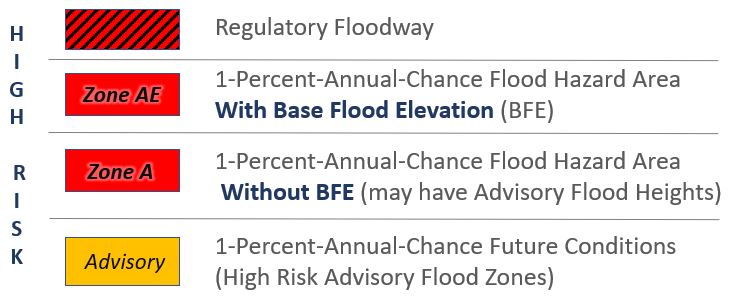
The Viewer displays the high-risk areas subject to inundation by a flood event having a 1-percent chance of being equaled or exceeded in any given year. The 1-percent annual chance floodplains are also known as 100-year floodplains or base floodplains. The base flood is the national standard used by the National Flood Insurance Program (NFIP) and all Federal agencies for the purposes of requiring the purchase of flood insurance and regulating new development. The Viewer also displays high-risk advisory zones (Advisory A and Updated AE) for a base flood event. These advisory zones were created from better topographic data and stream flood models and most likely will become effective, regulatory flood zones upon the completion of FEMA restudies.
Flood Zone Legend:
Floodway – black diagonal lines
Effective Flood Zone (AE, AO, AH, A) - red
Advisory A / Updated AE - orange
For assistance in determining if your property is in the flood zone, contact your local or state Floodplain Managers.
You should contact your local assessor about any errors you believe exist in your property record information, e.g., misspelled name, wrong street address, etc.
The property record information in the Viewer is updated annually when the WV Property Tax Division releases the new tax assessment information. If you recently purchased an existing piece of property and no property lines were altered (simple change of ownership of an existing piece of property), it is likely that the information has not filtered up to our site yet.
What if my property record is right, but the Viewer still shows the old parcel lines or my property parcel on the map does not exist? The property information available on the Viewer is provided in various forms to the State by the local county assessors. In some cases, the geometry (line work) is maintained electronically by the local assessor and moves quickly to the State and thus into the Viewer. In other cases, the county assessor maintains the geometry in a paper environment and it can take several years to be converted into a digital product and incorporated into the Viewer.
If your recent purchase resulted in new property lines being established (e.g. you purchased five acres out of a ten-acre property), the property will not appear on our site until after the county has submitted the parcel changes to the WV Property Tax Division. For property transfers occurring between July 1st and June 30, assessors are required to have tax maps revised and submitted to the WV Property Tax Division no later than February 1 of the subsequent calendar year. Therefore, contact your local assessor if your parcel lines on the tax map have not been updated after two years of the property transfer.
Many county assessors have their own parcel web viewers which are an alternative source to verify real estate property information. In addition, the assessor’s published full-version tax maps for the entire State can be accessed online.
A PDF file of any full-version tax map in can be accessed by a web browser using the following URL parameters: https://www.mapwv.gov/taxmaps/?m=02-04-037M (County Code - District No. - Map ID). Contact the office of your county assessor if you have questions about the parcel geometry or attributes.
Property maps, maintained by your local county assessor’s office, are a best-fit visualization of how all the properties in a county relate to one another. The property lines are determined by examining detailed property descriptions on deeds and by using surveys created by a licensed surveyor but are not conclusive evidence of property ownership in any court of law.
If you feel your property is drawn in error, you should contact your county assessor’s office and work with them to resolve the discrepancy. If you have a deed or survey of your property, that will be helpful to the assessor's office personnel. You can find the contact information for your local Assessor at this link.
No. The parcels represented here are for property tax assessment purposes only and do not represent legal boundaries of property. As co-custodians of the tax maps, the assessors and the WV Property Tax Division shall have no liability to any third party for any errors or omissions associated therewith or in connection with the use of tax maps for any other purpose.
In West Virginia the county assessor is responsible for maintaining the surface property tax maps. While this Viewer makes every effort to make the best available data accessible to the public, the office of the county assessor is always going to be the most accurate and up to date source for assessment information. Here is a link to contact information for county assessors in West Virginia.
The WV Property Tax Division annually creates a master surface tax parcel file from the GIS parcel files provided by the county assessors and the property attributes from the centralized Integrated Assessment System (IAS). Both the WV Property Tax Division and county assessors are co-custodians of the tax maps and GIS files.
The passing of SB 588 in July 2017 permitted the WV Property Tax Division to allow all digital surface tax maps and GIS files to be downloaded at no charge. These digital files can be downloaded from an authorized tax map distribution site located at the State Data Clearinghouse.
What about privacy concerns that your property information is posted on the Viewer? Recent court case decisions and approved legislation in West Virginia have deemed that property record information and maps are not private information. This includes the collection, storage, retrieval or aggregation of information about an individual that is publicly available from legal information found in deeds, property records, and property maps. Sensitive information such as telephone numbers and security alarm systems are redacted from the property records before released to the public.
The Parcel ID is a unique number that is the basis for identifying all parcels. The Parcel ID consists of six elements: County code, District code, Map number, Parcel Prefix, Parcel Suffix, and Special ID. All the elements are alpha-numeric characters except for the county and district codes which are numeric. The Root Parcel ID (e.g., 31-05-0007-0031-0015-0000) consists of all six elements separated by hyphens.
GIS Parcel ID: 31-05-0007-0031-0015
County: 31 (Monongalia County)
District: 05 (Clinton District)
Map: 7
Parcel Number: 31
Parcel Suffix: 15
The Viewer displays various formats of the Parcel ID. The GIS Parcel ID consists of all elements minus the Special ID (e.g., 31-05-0007-0031-0015) while the CAMA/IAS Parcel ID consists of all elements minus the county code (e.g., 05 7003100150000). The Viewer also displays abbreviated Parcel IDs in which leading zeros or spaces are removed. Examples include the parcel number search results that consist of the District-Map-Parcel (e.g., 05-7-31.15) or the parcel map labels denoted by Map-Parcel (e.g., 7-31.15).
The viewer does not identify stacked parcels. Stacked parcels identification is available in the WV Property Viewer. The Parcel Assessment Report displays assessment information at multiple buildings in a single parcel.
The municipal and county addressing offices periodically submit up-to-date E-911 addresses to the Statewide Addressing and Mapping System (SAMS) maintained by the WV Division of Homeland Security & Emergency Management. Contact your local E-911 addressing office if your street address is not correct.